|
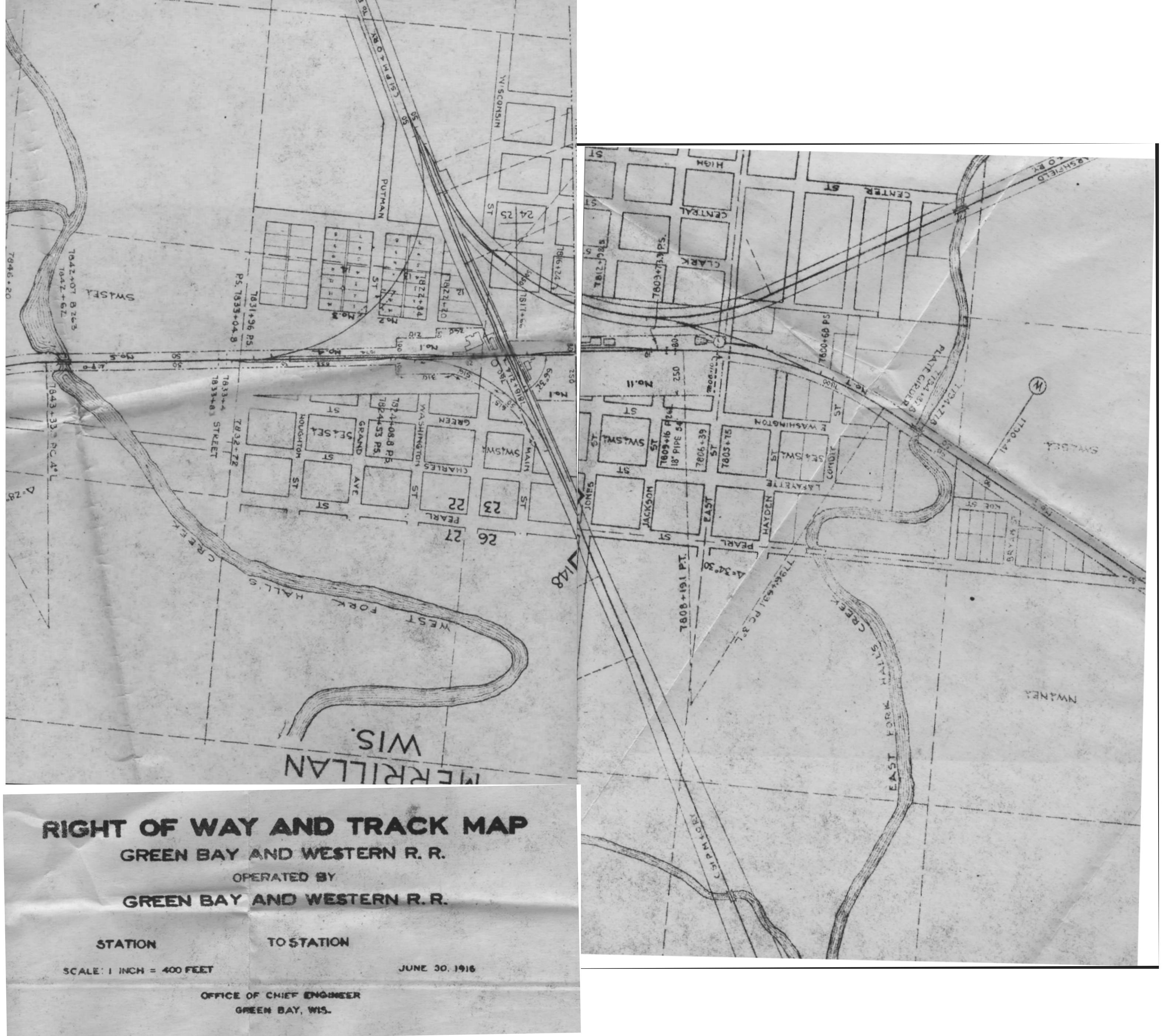
Right-of-way map of Merrillan issued by the Green Bay & Western in
1916.
The map is arranged with north to the top. The Green Bay &
Western main line runs east-west through Merrillan and the Omaha Road
(CStPM&O) goes north-south, with their branch line to Marshfield
heading off in a northeast direction.
Prominent details on the map include:
- The Union Depot, which is the small building in the
northwest corner of the crossing. The depot is still standing
and in use today.
- The freight depot in the southeast corner of the
diamond. Both the passenger and freight depots were used by both
railroads.
- The Hotel Campbell, the large building west of the depot
which was the railroad eating house for passengers making connections
between the GB&W and CStPM&O.
- The GB&W water tank in the southwest corner of the
junction.
- The turntable and two stall engine house lies further to the
east. Both railroads used the engine house.
- The Marshfield Branch of the Omaha Road heads off to the
northeast.
- A pickle plant located on the GB&W main line between the
crossing and the engine house.
Because this map was issued by the GB&W it doesn't show the Omaha
Road water tower which was on the east side of their main line, across
from the depot. Nor does it show the Omaha Road's coal shed which
was located north of the crossing.
These maps also listed the original sellers of the land that the
railroad bought along the right of way and the amount of land purchased.
A great big thanks goes out to Bob Gile for providing this
fantastic map and information on the prominent features.
If you really want to see this map in detail, follow this link for an enlarged copy
of the map (3168x2805, 699 kB).
Related material:
- St. Paul Extension (ca. 1892) - A
map published by the Village of Merrillan shows the proposed Green Bay
Route's extension with Merrillan as a major division point.
- Omaha Road Crossing (1907) - The
GB&W and Omaha Road crossing at Merrillan.
- Trains in Merrillan (1913) - Lots of
trains thru Merrillan, Wisconsin.
- Merrillan Map (1916) - Right-of-way
map of Merrillan issued by the Green Bay & Western in 1916.
- Turntable Wreck (1920) - An
overturned coach sits next to the Merrillan turntable.
- Plow Train (1969) - A westbound plow
train approaching Sand Road on the west edge of Merrillan.
- Merrillan Crossing (1976) -
Eastbound Train No. 2 passes the Merrillan depot painted in
"C&NW 400" colors.
- Merrillan (2001) - Ex-GBW / Omaha
Road Merrillan Depot, now used by the Union Pacific.
|