Search greenbayroute.com:
Green Bay & Western Lines
The East-West Short Route
 [Home]     Information ] Locos ] Rolling Stock ] Photos & Stuff ] Ephemera ] Modeling ] References ] Site Map ]
Sturgeon Bay Ship Canal

Up ]

Home

Information
Locos
Rolling Stock
Photos & Stuff
Ephemera
Modeling
References
Site Map

What's New?
Guest Book


In the Beginning...
Eastmoor
GB&LP Headquarters
New London Junction
Kewaunee Harbor
Arcadia Washout
Manawa Wreck
Iola & Northern
Ice Jam
St. Paul Coal Docks
Cargill Coal Docks
Hatfield Dam Const.
Omaha Road Crossing
Sturgeon Bay Ship Canal
Wisconsin River Crossing
Waupaca Station
Waupaca Train
Sturgeon Bay Bridge
Stevens Point
Kewaunee
Grand Rapids Bridge
Amherst Junction
Amherst Junction Depot
Big Crowd At Blair
Kewaunee Bridge
Hatfield Bridge
Black Creek Yards
Whitehall
Grand Rapids Bridge
Green Bay Junction
Taylor 1909
Scandinavia Depot
Scandinavia Union Depot
Grain Elevator
Luxemburg
C&NW Bridge Yard
Shiocton Bridge
Station "66"
Amherst Junction
Deer Hunting
Kewaunee Skyline
Manawa Depot
Amherst Junction
Shiocton Street Scene
Trains in Merrillan
Scandinavia Map
Arcadia Excursion
Seymour Station
Sturgeon Bay Depot
Green Bay Station
Merrillan Map
Green Bay Depot
Manawa Station
Turntable Wreck
Arnott Depot
The Crew of No. 23
Amherst Junction
Sturgeon Bay Map
Sturgeon Bay Aerial
Sturgeon Bay Yard Action
WRX at Cheeseville
Whitehall Depot
Scandinavia
Sampson Canning
Swing Bridge
Green Bay Aerial
Door County Cherries
Casco Junction derailment
Smith Shipbuilding
Steam in Color
#251 in Sturgeon Bay
Reiss Coal Crane Collapse
Hatfield Gravel Pit
Kewaunee Car Ferries
Wis. Rapids Depot Staff
Algoma Hardwoods
Kewaunee
Old Wis. Rapids Depot
New Wis. Rapids Depot
Winona Yard
Sturgeon Bay Track Plans
Green Bay Food Company
Merrillan Bridge Collapse
Merrillan Train
New Halls Creek Culvert
Sturgeon Bay
1969 Train Wreck!
#312
Green Bay Station
Wisconsin Rapids Aerial
Casco Depot
Sturgeon Bay Aerial
Mississippi Bridge Approach
Oneida Hill
Loading the Ferry
Norwood Elevator
1976 AHW Excursion
Merrillan Crossing
Winona Bridge
Trempealeau Valley Limited
Plover Depot
Stevens Point
Norwood Shops
1978 AHW Excursion
Taylor, Wis.
Kewaunee ca. 1980
Winona Enginehouse
New Power at New London
Winona Bridge
Fouling the Diamond
Sand Road
Kewaunee Car Ferriy
Train No. 2 at Merrillan
East Halls Creek
Westbound No. 2
Black River Bridge
Eastbound Pulpwood at Rapids
'85 Snow Plow Train
Train 2
No. 2 at Norwood
Alma Center
Train 2 at Merrillan
Ballast Train
Broadway Tower
'Valley Line' Train
East of Whitehall
James River Job
Norwood Shops
#309 at Del Monte
The End...
Farewell Excursion
End of the AHW
AHW Enginehouse
Luxemburg Co-Op
End of Norwood
Bridge at Dodge
Winona Today

  
Did you know...


Reload this page for more GREEN BAY ROUTE facts.
 

View of the Sturgeon Bay Ship Canal and the Ahnapee & Western crossing of the water.


This 1907 view of Sturgeon Bay is looking east from the town of Sawyer across the Sturgeon Bay Ship Canal.  The Ahnapee & Western track from Maplewood curves out on a trestle over the water.  The roadway which connects with the trestle on the left side of the photo is the highway structure.  The main span of the bridge was shared by both railroad and highway traffic.

The famous swing bridge is at the far end of the crossing, barely visible in this view.

1907 was a time of great change  for the A&W.  The Green Bay & Western acquired a majority of the A&W's stocks and bonds, and added the railroad to the Green Bay Route.  For a while, Sturgeon Bay served as the eastern end of the route, with Kewaunee acting as a branch.  The railroad actively competed against steamship lines, coordinating their scheduled passenger service with Chicago & North Western railroad connections from Chicago.  The importance of the car ferries to the livelihood of the line, along with a decline of business in Sturgeon Bay and the impact of the automobile on tourism ultimately made Kewaunee the main line termination and the A&W was a 57-mile branch line.

Related material:

  • Sturgeon Bay Bridge (1908)
    A turn-of-the century view of the trestle approach and swing bridge over the Sturgeon Bay Ship Canal.
  • Sturgeon Bay Map (1925)
    This map was issued May 27, 1925 by the U.S. War Department.
  • Sturgeon Bay Aerial (1929)
    Postcard view shows the city of Sturgeon Bay and the Ahnapee & Western's crossing of the Sturgeon Bay Ship Canal.


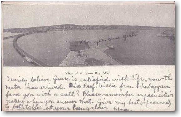
Postcard, dated November 28 1907.

[ Top of This Page


 The Green Bay Route is maintained by Mark Mathu.
Visit the Guest Book or send comments to mark@mathu.com.
Updated July 11, 2015